
This section covers classification of maps and charts. While many maps use classification numbers that are constructed according to the general rules in previous sections, this section covers numbers that are derived from elements other than a Cutter or series number, including maps such as the U.S. Geological Survey (USGS) 7.5 minute quadrangle maps and related U.S. Forest Service (USFS) maps. Federal agencies which have produced maps included the Defense Mapping Agency (DMA), which was folded into the National Imagery and Mapping Agency in 1996; this became the National Geospatial-Intelligence Agency in 2004.
Category Classes for Maps and Charts
As noted in the Category Classes section, maps and charts are classed under the category .11.
In basic terms, a map is a representation of geographic features of the Earth. An example is a topographic map, which contains contour lines to show elevated geographic surfaces and labels or symbols for significant landforms. A chart can be defined as a map, either nautical or aeronautical, designed primarily for navigation, or a sheet exhibiting information in a tabular or graphic form.
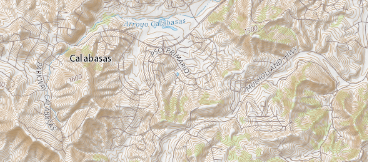
Detail of Calabasas, California quadrangle map from the USGS Map Locator tool showing topographic lines, elevation numbers, and labeled landforms.
Only cartographic material designed primarily for terrestrial, nautical, or aeronautical navigation should be classified as a map or chart. Tabular or graphic charts such as those representing data or statistics should be classified as series documents, posters, or general publications.
Publications which consist of a combination of cartographic, textual, or other illustrative content and are designed to inform visitors of parks, historical sites, etc. should not be classified as maps or charts, even though they may be cataloged as maps or charts. These publications have their own classes.
Example
| I 29.6:G 79/12/2018 | Great Basin National Park, Nevada |
In the above example, the publication is cataloged on a maps workform, and includes a Physical Description (MARC field 300) of “1 map.” Although it is treated as a map for cataloging, it is classed in I 29.6: which is the class stem for the National Park Service’s information circulars about national parks. It is not classed in I 29.8: which is the class stem for maps from the National Park Service.
If individual class stems have not been established, publications combining cartographic and other informative content should be treated under the general rules for classification.
In order to be consistent with past practice, maps issued in numbered series should continue to be classed in that series. Maps issued as U.S. Geological Survey open-file reports (I 19.76:) are an example of this type of material.
Example
| I 19.76:2016-1021 | Ecoregions of California |
However, new bureaus, offices, departments, etc., will have separate category classes for maps and charts.
General Rules
- The elements that make up the book number—the number that follows the colon in the classification number and uniquely identifies the publication—are frequently displayed on the map itself and should be used in the classification number without alteration, with the exception of SuDocs classification elements such as spacing (described below). If the elements are not displayed, they must be derived from other sources.
- Numbered map sequences follow Cuttered map sequences within the same class stem; there is no need to establish separate class stems for each.
- A map may be created by one agency, but then revised and reissued by a second agency. These revised and reissued maps are classified under the new issuing agency, even though the bibliographic information relating to the first agency is most prominently displayed on the map.
U.S. Geological Survey Maps
The largest group of U.S. Government maps is issued by the U.S. Department of the Interior, U.S. Geological Survey.
Example
“Most USGS map series divide the United States into quadrangles bounded by two lines of latitude and two lines of longitude. For example, a 7.5-minute map shows an area that spans 7.5 minutes of latitude and 7.5 minutes of longitude, and it is usually named after the most prominent feature in the quadrangle. Others show a whole area—a county, state, national park, or place of special interest. The best known USGS maps are those of the 7.5-minute, 1:24,000-scale quadrangle series. A scale of 1:25,000 is used for maps based on metric units (1 centimeter = 0.25 kilometer). The area portrayed on each sheet ranges from 64 square miles at latitude 30 degrees north to 49 square miles at latitude 49 degrees north.” (USGS Maps site)
Once the class stem for the agency is designated, the book number for a USGS map is derived from various elements. The book number following the colon is unique to map identification and includes the map coordinates, map reference number, map type, scale, and edition date. These elements are separated from each other by dashes. The edition date is added after a slash at the end of the class as new versions are published.
Example
| I 19.81:34118-B 6-TF-024/2012 | Calabasas quadrangle, California: 7.5-minute series |
Breakdown of the class number after the USGS agency stem:
Example
See the sections below for details on the Map Reference Numbers and Map Types.
Though developed specifically for USGS quadrangles, the map reference number is also used as necessary in other map classes, especially in Forest Service maps based on USGS quadrangles.
The book number as derived from this map is 34118-B6-TF-024. According to rules set forth in Structure of the Classification Number, a space must be inserted between letters and numbers in the classification number, unless there is intervening punctuation. The result is the addition of a space between B and 6 in the classification number.
Coordinates
Map coordinates are composed of the degrees, minutes, and seconds of latitude and longitude. As explained below, latitude and longitude are combined to create the coordinate element of the SuDocs classification number.
The coordinates are represented by a 5-digit number displayed in the lower right hand corner of this map of the Tonto Basin region of Arizona from 2004, in this case, 33111:
Example
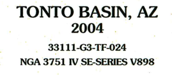
The 5-digit coordinate number, 33111, is derived from the map coordinates in this USGS map from 2004.
More recent maps may no longer display the 5-digit coordinate number. If the 5-digit coordinate number is not displayed on the map, it can be derived from the coordinates shown at the lower right corner of the map sheet. The numbers on the upper right represent the latitude (north); the lower left numbers represent the longitude (west).
Example
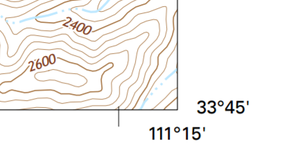
The lower right corner of this Tonto Basin, Arizona map from 2014 shows the latitude and longitude (in degrees and minutes) of the coordinates.
Latitude can range from 0 to 90 degrees, while longitude can range from 0 to 180 degrees. Using the example above:
Example
- Latitude (north-south) is represented by the number 33: 33° 45’ (33rd latitude)
- Longitude (east-west) is represented by the number 111: 111° 15’ (111th longitude)
In SuDocs maps classification:
- Only the degrees are used in the coordinate element of the classification number.
- The first number, latitude, is represented by a 2-digit number.
- The second number, longitude, is represented by a 3-digit number.
- Leading zeroes are used as necessary to make up the 2- or 3-digit numbers to create the 5-digit coordinate number combination.
Using the following coordinates, we can derive a significant element in the suffix of the classification number:
Example
Using these degrees, the coordinates are represented in the class number as 33111. The classification number for the Tonto Basin, Arizona map from 2004 would be:
Example
I 19.81:33111-G 3-024/2004
For maps in the northeast or southeast quadrant of the globe, add 180° to the east coordinate found in the lower right corner of the map. For example: if the map reads 40° north and 75° east, add 180 to the east number (75+180=255) and use the number 40255 (40° north, 255° east) for the coordinate element of the class number.
Map Reference Numbers
The map reference number element of the classification number is an alphanumeric identifier that indicates the general geographic location represented by a map. It is derived from the minutes and seconds of the coordinates in the lower right corner of the map.
The most frequently used numbers for U.S. maps are for the northwest (NW) quadrant of the globe which includes the United States.
Using the following example, we determine the map reference number by using the minute and second numbers that follow the degrees in these coordinates:
Example
- Use 37’30” to match against the numbers in the North column on the grid below.
- Use 52’30” for the West numbers.
- Find the designated map reference number: F 8.
If the seconds or minutes are not printed after the degrees on the map, assume they are 0.
Use the following guidelines to determine the map reference number for each NW, NE, SW, and SE quadrant.
Northwest (NW) Quadrant
- From the lower right corner of the map, select north minutes and seconds.
- Match these to the same numbers in the North column below.
- Select the west minutes and seconds from the map and match these to the corresponding West column.
- Use the alphanumeric identifier from the No. column in that row to construct the classification number.
Northwest Quadrant
Northeast (NE) Quadrant
- Follow instructions for northwest quadrant above, but select the east minutes and seconds and match these to the corresponding East column below.
- Use the alphanumeric identifier from the No. column in that row to construct the classification number.
Northeast Quadrant
Southwest (SW) Quadrant
- From the lower right corner of the map, select south minutes and seconds.
- Match these to the same numbers in the South column below.
- Select the west minutes and seconds and match these to the corresponding West column.
- Use the alphanumeric identifier from the No. column in that row to construct the classification number.
Southwest Quadrant
Southeast (SE) Quadrant
- Follow instructions for southwest quadrant above, but select the east minutes and seconds and match these to the corresponding East column below.
- Use the alphanumeric identifier from the No. column in that row to construct the classification number.
Southeast Quadrant
Scale
The map’s scale is represented in the class by 3 numbers. These typically appear on the map as the last element in the sequence of numbers and are used for the classification number.
Example

In this 2004 map, the last 3 numbers of 33111-G3-TF-024 (024) represent the map’s scale.
In this example, 024 signifies that the scale is 1:24,000 (1 inch = 24,000 inches or 2,000 feet).
If this string of numbers does not appear on the map (such as in newer maps), determine the number from the scale statement. Use the portion of the number between the colon and the comma (:24,) and insert leading zeroes as necessary to make up 3 digits. When creating a classification number, add a leading zero to equal 024.
Example
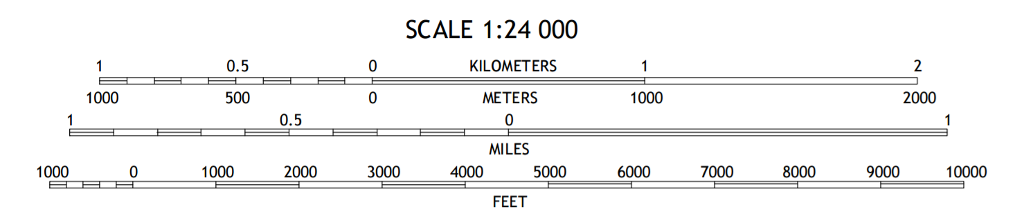
Image showing scale of 1 to 24,000, or 024.
For more information on map scales, see the U.S.G.S. Fact Sheet on Map Scales.
Edition Date
The final element, the edition date, is represented by a 4-digit year from year 2000 forward (also used prior to 1900). A 3-digit year format (the last 3 digits of the year) was in use from 1900-1999.
Example
| I 19.110:33111-E 1-TM-100/994 | Theodore Roosevelt Lake, Arizona (1994) |
| I 19.110/4:33111-E 1-TM-100/2017 | Arizona: Theodore Roosevelt Lake (2017) |
USGS maps are available at the USGS Maps website.
Bureau of Land Management Maps
The U.S. Department of the Interior Bureau of Land Management (BLM) produces maps for its surface management series. GPO catalogs these maps as serials, as described in Cataloging Decision: Monograph vs. Serial and Frequency of Issuance. The class stem for the series is I 53.11/4:.
GPO classifies these maps using a double Cutter as the book number.
- Include the following elements in the book number in this order:
- State Cutter number
- Forward slash (/)
- Local geographic area Cutter number; follow the guidance in Cuttering: Geographic Topics
- Forward slash (/)
- This slash indicates the continuing nature of the resource.
- Follow the spacing conventions described in Structure of the Classification Number
Example
I 53.11/4:N 41/T 48/ Nevada. Timpahute Range : 1:100,000-scale topographic map
[ “N 41” is for Nevada, and “T 48” is for the Timpahute Range.]
In past practice, GPO cataloged BLM maps as monographs and used the map number as the book number.
Example
I 53.11/4:44118-E 1-TM-100/2017 Oregon: Bates: 1:100,000-scale topographic map
[“44118-E1-TM-100” is the map number as found on the item; “2017” indicates the edition date]
U.S. Forest Service Maps
The U.S. Department of Agriculture’s Forest Service publishes maps that are Cuttered under the name of the geographic area—forest, wilderness, etc.—and are classified according to the general rules of SuDocs classification.
Example
| A 13.28:F 88/9/2017 | Bly Ranger District, Fremont-Winema National Forest |
| A 13.36/2-6:D 22/2/2014 | Daniel Boone National Forest, Stearns Ranger District |
Note that prior to October 2014, Visitor/Recreation Guides for National Forests were Cuttered under the series numbering on the map, rather than the name of the forest.
Example
| A 13.36/2-6:R 5-RG-172 | Lake Tahoe Basin Management Unit |
The Forest Service also revises and reissues U.S. Geological Survey quadrangle maps; a typical example is the U.S. Forest Service revising and reissuing U.S. Geological Survey 7.5 minute quadrangle maps of the national forests. These maps may have ‘Modified for USDA Forest Service Use’ or similar verbiage displayed on the map.
Example
| A 13.28:SH 2/985/37089-F 5 | Shawnee National Forest |
| (CGP notes: “Geological Survey ; modified for USDA Forest Service use”) | |
For these maps, use the Forest Service information rather than the USGS information when possible in constructing the class number.
Each forest map consists of a number of sheets as shown by the quadrangle location diagram at the bottom of the map. When all of the sheets for one forest are put together, they form one map, not many maps. Therefore, all the sheets of these modified quadrangle maps are Cuttered under the name of the forest, rather than under the individual quadrangle sheet name. The forest name generally appears in the lower right corner of the sheet.
If a separate map is issued for the same area, and it is not a new edition of an existing map, use the same Cutter number and add the next available slash number. Check the Catalog of U.S. Government Publications (CGP) or other bibliographic utility carefully before creating a new slash number to ensure that the number has not been previously assigned.
Example
| A 13.28:C 23/5 | Carson National Forest, New Mexico (1967; revised 1975) |
| A 13.28:C 23/6 | Carson National Forest, New Mexico, 1986-1987 (A separate map, not a new edition of the previous map) |
| A 13.28:C 23/6/991 | Carson National Forest, New Mexico (A newer 1991 edition of the second map) |
| A 13.28:C 23/6/2013 | Carson National Forest, New Mexico (Reprinted 2013) |
Once the Cutter and slash numbers have been established for a particular set of 7.5 minute sheets that make up the map for a forest, the Cutter and slash number remain the same for later editions of the same set. Only the year changes in the classification number.
A slash and the 4-digit year (last 3 digits prior to 2000) of the latest edition date are added after the Cutter, or after the slash number, if there is one, to keep all sheets of the set together.
After the date, add a slash followed by the map coordinates and map reference number using the Map Reference Number table for the individual maps within the forest.
Revision Dates
Map dates can be unclear because many quadrangles are under constant review. There are specific periods for revision, but occasionally changes are inserted without altering the original date information. Check the printing or publication date, edition statement, and other areas of the map to determine if it is a reprint with changes. Take care when examining a map to confirm whether it is a duplicate reprint or a revised edition.
Edition statements may include ‘revised,’ ‘field checked,’ (in older cases, ‘photorevised,’ ‘photoinspected,’ or ‘provisional edition’) or other wording showing that the map differs from a previous version.
Example
| A 13.28:B 48/5/2010 | Bighorn National Forest, Wyoming (2010 edition; CGP record notes ‘Field checked 2006’) |
Always add the most recent edition date to the class, unless the edition number is part of the numbering sequence.
Dates on maps vary in both form and presentation and may include the following:
Date of map information, usually shown with the title:
Example
| A 13.36/2-9:D 45/2017 | 2017 central Oregon personal use firewood maps |
Date of edition, shown with the edition statement: ‘Revised (Year).’ This date is used at the end of the quadrangle class to distinguish it from other editions of that specific quadrangle:
Example
| A 13.36/2-6:C 59/2016 | Cleveland National Forest Atlas: 7 ½’ quadrangle topographic maps (CGP record notes ‘Revised and printed 2016’) |
Another type of date may reflect the date of publication, shown in imprint, colophon, etc. This date is used in large sets of maps (e.g. large forest map sets) to group all sheets of the set together for the year. The publication date in these large map sets is put before the coordinates and the rest of the elements of the map classification number. A date may also represent the date of reuse or revision of the map by a second agency.
If no date is displayed on the map, check the shelflist or Catalog of U.S. Government Publications (CGP) for a record with similar bibliographic information. If there is a similar record, check with the issuing agency to see if the map in question is a duplicate or a revised edition.
National Ocean Service Nautical Charts
The National Ocean Service (NOS) is an agency within the U.S. Department of Commerce, National Oceanic and Atmospheric Administration (NOAA) that produces nautical charts. Nautical charts display the coastline next to a landform and include water forms, water depths, and other elements
Class NOS nautical charts using the agency’s numbering system as shown on the chart and include the 4-digit year of the edition.
Example
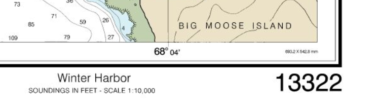
Nautical chart of Winter Harbor, Maine with NOS number 13322 in lower right corner.
The classification number for the Winter Harbor map would be
Example
| C 55.418/7:13322/2012 | United States--east coast, Maine, Winter Harbor |
National Ocean Service nautical charts are usually classed with the agency numbering system as shown on the chart and are rarely Cuttered. If there is no NOS number, the Stock number may be used (often the same number).
Example
| NOS number: | 14845 |
| Stock number: | 14845 |
| Edition date: | 2014 |
Resulting classification number:
Example
| C 55.418/7:14845/2014 | United States--Great Lakes, Lake Erie--Ohio, Sandusky harbor |
Map Types
Map types are designated by two letter abbreviations. Of the many map types, the two most frequently occurring are:
| • TF | Topographic (feet) |
| • TM | Topographic (metric) |
Abbreviations of map types in use or previously used in class numbers:
| AB | Alaska Boundary Series Index |
| AF | Alaska Boundary Series National Forest System |
| AL | Alaska Boundary Series Bureau of Land Management System |
| AP | Alaska Boundary Series National Park System |
| AW | Alaska Boundary Series National Wildlife Refuge System |
| CF | County (feet) |
| CM | County (metric) |
| CP | County (planimetric) |
| EI | Ecological Inventory |
| LB | Land Use and Land Cover (base) |
| LM | Land Use and Land Cover (multicolor) |
| MM | Surface Minerals Management Status |
| NA | National Atlas (separate sales) |
| OM | Orthophotomap |
| OQ | Orthophotoquad |
| PF | National Park, Monument (feet) |
| PI | Photo Image Map |
| PL | Planimetric |
| PM | National Park, Monument (metric) |
| PR | National Park, Monument (shaded relief) |
| RA | Radar (airborne) |
| RF | Regional (feet) |
| RM | Regional (metric) |
| RP | Regional (planimetric) |
| RR | Regional (shaded relief) |
| RS | Radar (satellite) |
| SI | Satellite Imagery |
| SL | Slope Map |
| SM | Surface Management Status |
| SP | State Base (planimetric) |
| SR | State Base (shaded relief) |
| ST | State Base (topographic) |
| TB | Topographic Bathymetric |
| TF | Topographic (feet) |
| TM | Topographic (metric) |
| TR | Topographic (shaded relief) |
| UB | United States (base) |
| UG | United States (general) |
| UM | United States (magnetic) |
| UT | United States (topographic) |
| WB | World (base) |
| WG | World (general) |
| WP | World (political) |
| WT | World (topographic) |